Vortigern
Studies Index


.Wansdyke Project 21
is part of
Vortigern Studies

|
|
| |

click here
|
|
Gary Pearce (Click each image to
enlarge it).
|
|

This
image shows Wansdyke just east of the River Chew
(looking west). (click here to
enlarge)
|
|

This image shows Wansdyke just east of
the River Chew (looking east).
(Click here to enlarge).
|

This
image is shot from the Compton Dando church
tower, looking east to Lye Hill. Wansdyke runs
through the middle of the picture. (click here to
enlarge)
|
|

This
image shows the same picture, but enlarged.
(click here to
enlarge)
|

The bridge across the River Chew at Compton
Dando.
(Click here to enlarge).
|
|
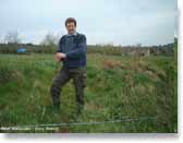
Mr.
Pearce on top of Wansdyke, east of Compton Dando.
(Click here to enlarge)
|

Two
shots of Maes Knoll. This one shows the 'Tump',
coming from the west. (click here to
enlarge)
|
|

On top
of the Tump, looking towards Bristol. (click here to
enlarge)
|
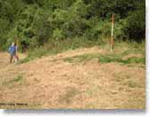
Wansdyke
emerging from Peppershells Plantation, summer
2002. (click here to
enlarge)
|
|
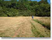
Wansdyke
seen traversing the recently trimmed meadow.
(click here to
enlarge)
|
Copyright © 2002,
Gary Pearce. All rights reserved. Used with permission.
Comments to: Gary Pearce
|


