Vortigern
Studies Index


.Wansdyke Project 21
is part of
Vortigern Studies

|
|
| |

click here
|
|
Rick Crowley (Click each image to
enlarge it).
|
|

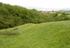
West
Wansdyke at Maes Knoll Tump, with Chew Magna
Reservoir in the background.
|
|

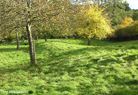
Maes
Knoll Tump, seen from the south.
|
|
West Wansdyke
near Compton Dando, running through an orchard at
ST654 643 |

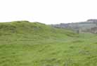
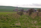
West Wansdyke
at Stantonbury Hill showing Wansdyke with a track
passing through it. |
|

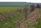
West
Wansdyke on the right with trees growing out of
it. |
|
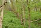
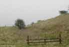
Still at
Stantonbury Hill, nearer the bottom of the hill
were it is very overgrown. |
West Wansdyke
at Englishcombe. |
|

West
Wansdyke emerging from Breach Wood, close to the
outskirts of Bath. |
|
West
wansdyke on rising ground south of Breach Wood,
with the houses of Rush Hill beyond.
|
East Wansdyke
at Red Shore, between Knap Hill and All Cannings
Down.
|
|
East
Wansdyke at Red Shore, between Knap Hill and All
Cannings Down.
|
|

East
Wansdyke at Red Shore, between Knap Hill and All
Cannings Down.
|
|
|
East Wansdyke
at Red Shore, between Knap Hill and All Cannings
Down.
|
|
|
Copyright
© 2010, Rick Crowley. All rights reserved. Used with
permission.
Comments to: Rick Crowley.
|


