Welcome to Wansdyke
Project 21, a unique web-based study which
focuses on the enigmatic, least-known Dark Ages
earthwork, known as Wansdyke. Edited by Robert M. Vermaat,
it features narrative histories, original source
documents and important texts, extensive
bibliographies, reading lists, informative
articles by guest writers, maps, polls and more.
Wansdyke Project 21 is part of Vortigern Studies,
which has the internet's most comprehensive
treatment of Britain's history from the end of
the Roman era to Arthurian times. |
Vortigern Studies Index


.Wansdyke Project 21
is part of
Vortigern Studies

|
|
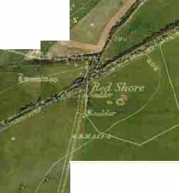
This
part of the Wansdyke Pages contains satellite
shots of each section of Wansdyke, as well as the
complete listing of Wansdyke in old parish maps,
dating from the 19th century.
Though
the maps of course are not exactly similar to the
description of the sections, they are listed a
close to them as possible.
For
detailed modern maps, please go to the directions
that accompany each section as it is described in
Wansdyke West to East.
The
image shows Red Shore, the gap where the famous
prehistoric thoroughfare, the Ridgeway, passes
through East Wansdyke. Satellite image with a
19th-century Parish Map superimposed.
|
|
Current
Contents:
West
Wansdyke
'Mid-Wansdyke'
and the Roman road?
East
Wansdyke
|
|