
Welcome to Wansdyke
Project 21, a unique web-based study which
focuses on the enigmatic, least-known Dark Ages
earthwork, known as Wansdyke. Edited by Robert M. Vermaat,
it features narrative histories, original source
documents and important texts, extensive
bibliographies, reading lists, informative
articles by guest writers, maps, polls and more.
Wansdyke Project 21 is part of Vortigern Studies,
which has the internet's most comprehensive
treatment of Britain's history from the end of
the Roman era to Arthurian times. |
Vortigern Studies Index


.Wansdyke Project 21
is part of
Vortigern Studies

|
|
This
part of the Wansdyke Pages contains the full
description of Wansdyke - its alignment, current
condition and alternative views. we shall start
from the hillfort of maes Knoll, bristol,
Somerset, passing Bath and the Avon valley to the
Marlborough Downs, Wiltshire. Maps and pictures
are added when available.
Also,
I aim to make access to the visitor as easy as
possible. Every section comes with a full
description of how to get there, accompanied by
maps from UkStreetmap.co.uk that should enable
the visitor to reach any point of Wansdyke
described here.
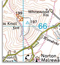
The
image shows Maes Knoll hillfort, generally
considered to be the most western point of
Wansdyke.
|
|
Current
Contents:
West
Wansdyke
'Mid'
Wansdyke / the Roman road
East
Wansdyke
|
|


