Vortigern
Studies Index


.Wansdyke Project 21
is part of
Vortigern Studies

|
|
Directions
to 'Mid' Wansdyke, Section 6
From the river
Avon to Morgan's Hill
Click on the map.
|
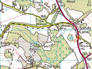
Point 6.1: From the Avon to
Verlucio Did the builders of Wansdyke ever
use the Roman Road? Here, east of the Avon, there
can be no substitute. And worse, the course of
the road is lost on the flanks of Bowden Hill. We
can retrace it only through Spye Park, as it
converges on Sandy Lane, once the small Roman
town (station) of Verlucio. From here,
it runs to Morgan's Hill, the point were Wansdyke
branches off.
|
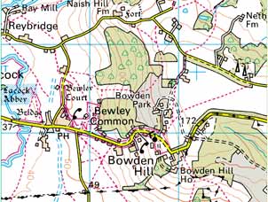
How to reach Wansdyke.. At
Wans House, the Roman station of Verlucio,
Sandy Lane
(all crossroads, etc. carry a link to UK Streetmap.co.uk).
From the west:
By car from
the direction of Melksham.
From Melksham: follow the A 3102 to
Calne, and the A 342 to Chippenham. Go right at Wans House, where you best park the
car. Right across the farm buildings is the agger,
the bank which forms the Roman Road. It should be
visible west of the main road, crossing a field
right into the woods of Spye Park.
Alternatively from Melksham: follow the A 350 to Chippenham,
and at Lacock go right. At this point, I’d
recommend a visit to the beautiful medieval site
of Lacock Abbey. Anyway, continue to Bewley
Common and Bowden Hill, from where a very steep
ascent will take you out of the Avon valley. The
road now leads you north of Spye Park and to
Sandy Lane, where you very briefly follow the A
342 south before going left at Wans House, and continue as
described above.
From the
north:
By car from
the direction of Chippenham.
From Chippenham: take the A 342 to Calne
and takes you past Sandy Lane, after which you
must turn left at Wans House, and continue as
described above.
Alternatively from Chippenham: take the A 350 to Melksham, but
turn left before Lacock to Reybridge,
which was the medieval Avon crossing of the
London-Bath main road. Continue uphill, on top of
which lies Naish Farm, which occupies the site of
a former hillfort. This site has the most
wonderful views across the Avon valley, and can
be spotted from the Cotswolds as well as the
Mendips. The minor road which continues to Sandy
Lane may, hypothetically speaking, be the route
on which one should look for Wansdyke IF
it once ran here from the Avon to Morgan’s
Hill. Arriving at Sandy Lane, you’ll very
briefly follow the A 342 south before going left at Wans House, and continue as
described above.
From the
south:
By car
from the direction of Devizes.
Take the A 342 to Chippenham, Go right at Wans House, where you best park the
car, and continue as described above.
From the east:
By car
from the direction of Calne.
Follow either the A 4 to Chippenham, or the A
3102 to Melksham, but take the A 432 from either
side once you reach it. Continue to Wans House,
then continue as described above.
|
Click on the map
|
Point 6.2: An alternative:
Naish Hill? I cannot but wonder why the
builders of Wansdyke did not use the hillfort at
Naish Hill. It is a vantage point that has views
from the Mendips to the Cotswolds, and even when
the Roman Road went out of use, the coaches still
passed by this point on their way from London to
Bath. The lane that runs from here to Sandy Lane,
could have been the ditch of Wansdyke. Who knows?
|
How to reach Wansdyke.. At Stockley
(all
crossroads, etc. carry a link to UK Streetmap.co.uk).
From the north:
By car from Swindon.
Follow the A 4361 to Wroughton and on to Avebury.
You will drive right through the ancient Stone
Circle and a visit can only be recommended! Drive
to Avebury through the roundabout, then take the A 4 to
Cherhill (there's a nice White Horse on the
hillside to your left), and on to Quemerford.
Take the road left (just before the Leisure
Centre) to Stockley. Drive on through the village,
where opposite the driveway of Harley Farm you'll
find the footpath which is the Roman road, going
west. From the village itself there's a footpath
towards Morgan's Hill and Wansdyke. Best park the
car there somewhere in the village.
From the west:
By car
from Calne and Chippenham. Follow the A 4
to Quemerford. Take the road to Stockley, then continue as
described above.
From the south:
By car from Devizes. Follow the A 361
to Avebury and Swindon, but after you passed
Bishops Cannings, take the first road left. The first crossing
after you've passed some cottages (but continue
on!) will be the Old Bath Road, the medieval
alternative of the Roman Road. To your left is
the 1643 Civil War battlefield of Roundway Down.
When you passed the golf course, you'll reach the
Morgan's Hill picnic site. Continue through the
hamlet of Blackland, take the road left and at the next crossing left again to Stockley,
and continue as described above.
Alternatively, if you don't mind a
good walk, park the car at the picnic site and
walk west across the foopath to Stockley.
From the east:
By car
from Marlborough. Follow the A 4 towards
Avebury and Quemerford, then continue as
described above.
|
Click on the map
|
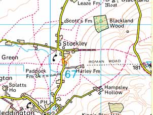
Point 6.3: Roman road at
Stockley This part of section 6 is the best
part of the Roman road east of the river Avon.
East of Spye Park, the course of the Roman road
is found again and becomes a good footpath from
Bell to Stockley across Broad's Green. From
Stockley, the path follows a course to the north
of the road, and after a mile crosses the road
opposite to the Morgan's Hill picnic area, just
short of the point were East Wansdyke disengages
itself from the Roman road.
|
click here to return to 'Mid'
Wansdyke, section 6.
|
