Vortigern
Studies Index


.Wansdyke Project 21
is part of
Vortigern Studies

|
|
Section 5:
Bath to the river Avon near Lacock
Wiltshire |
  |
| |
click here for directions to
Section 5 |
For
starters, another word of warning: 'Mid' Wansdyke is even
less pronounced compared to West Wansdyke, even worse: it
is not even that sure this was part of Wansdyke AT ALL!
So why do I mention it, let alone give it that much
attention? Well, that's easy; I'm not so sure that it is
NOT Wansdyke. I'll take you through the arguments
briefly.
 The reasons to disqualify this
section as part of Wansdyke are very straightforward. To
start with, there's no sign whatsoever of a ditch, just a
bank. In fact, we can be absolutely sure that this was
the ancient Roman road from London to Bath, and the bank
really is the agger or raised course of the
Roman Road. This means no defensive structure exists
here. Even worse, as Anthony Clark has rightly argued,
any defenders would have been trapped by the Avon at
their backs had any enemy attacked here. Which means that
this part, if ever belonging to the total scheme
of Wansdyke, would not only have been indefensible, but
probably unpatrolled as well. That would leave Wansdyke,
if it ever existed here, being a demarcation only.
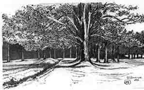
Nevertheless, as this 1819 sketch by Skinner of the Roman
Road across Neston House shows (click here to enlarge), it seems quite easy
to mistake the agger or bank of the road for a
linear earthwork. This has happened elsewhere in
Wiltshire (the Ackling Dyke). In my article about the relation of the Roman
road to East and West Wansdyke, I discuss these problems
at lenght. The reasons to disqualify this
section as part of Wansdyke are very straightforward. To
start with, there's no sign whatsoever of a ditch, just a
bank. In fact, we can be absolutely sure that this was
the ancient Roman road from London to Bath, and the bank
really is the agger or raised course of the
Roman Road. This means no defensive structure exists
here. Even worse, as Anthony Clark has rightly argued,
any defenders would have been trapped by the Avon at
their backs had any enemy attacked here. Which means that
this part, if ever belonging to the total scheme
of Wansdyke, would not only have been indefensible, but
probably unpatrolled as well. That would leave Wansdyke,
if it ever existed here, being a demarcation only.
Nevertheless, as this 1819 sketch by Skinner of the Roman
Road across Neston House shows (click here to enlarge), it seems quite easy
to mistake the agger or bank of the road for a
linear earthwork. This has happened elsewhere in
Wiltshire (the Ackling Dyke). In my article about the relation of the Roman
road to East and West Wansdyke, I discuss these problems
at lenght.
From Bathford
across the plateau..
The start of this
section bring us into serious difficulty. Though it has
been accepted with as fairly certain that the Roman Road
from Bath to London started at Batheaston, its course
uphill through Bathford is obliterated. It may have
followed the road to Ashley Wood, but upon reaching the
steep hillside its course is unknown, without any sign of
Wansdyke. Though Major & Burrow re-created a course
along the eastern escarpment of the Avon valley, the
parish maps show so much signs of quarrying that we may
safely assume that any remains, had they been
there, have long since been obliterated by industrial
avtivity. At the crest of the Ashley Wood escarpment, in
a point that forms the border between Somerset and
Wiltshire, the former course of the Roman Road is known
again. However, do not expect to find any signs of it,
apart from those visible to the expert field-walker and
archaeologist, or maybe when the light is favorable.
 The Roman Road now heads east in
the usual dead straight line, along the north edge of
Kingsdown Plantation, where a drawing by Burrow in 1925-6
showed a wall delineating its course. Only after crossing
the Kingsdown – South Wraxall road north of Hazelton
Wood, the agger of the Roman Road is visible for a
very brief time north of Chestland Wood, as can be seen
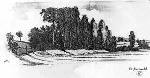
on this drawing of 1926 (click here to enlarge). From here,
Colt-Hoare observed that it followed a trackway marked as
Bulcot Lane, but which had disappeared by 1926. The Roman Road now heads east in
the usual dead straight line, along the north edge of
Kingsdown Plantation, where a drawing by Burrow in 1925-6
showed a wall delineating its course. Only after crossing
the Kingsdown – South Wraxall road north of Hazelton
Wood, the agger of the Roman Road is visible for a
very brief time north of Chestland Wood, as can be seen
on this drawing of 1926 (click here to enlarge). From here,
Colt-Hoare observed that it followed a trackway marked as
Bulcot Lane, but which had disappeared by 1926.
From Neston Park
to Spye Park.
 The next visible part is above
Norbin Farm, just west of the B 3109. From there, until
it crosses the A 365 in a woodland adjoining Neston Park,
the remains of the Roman Road are lost again, though
Burrow claimed in 1926 he had encountered the bank
standing as high as 12 feet cross the entrance to the
once much larger park (Cottles Wood). As the modern
Pathfinder map does not show it, I really doubt its
survival. Further to the east, past Medleys Cottages, a
bank can be seen again, though Burrow saw it still
flanking the road between Atworth and The Ridge in 1926,
as we can see from his drawing (click here to enlarge). The next visible part is above
Norbin Farm, just west of the B 3109. From there, until
it crosses the A 365 in a woodland adjoining Neston Park,
the remains of the Roman Road are lost again, though
Burrow claimed in 1926 he had encountered the bank
standing as high as 12 feet cross the entrance to the
once much larger park (Cottles Wood). As the modern
Pathfinder map does not show it, I really doubt its
survival. Further to the east, past Medleys Cottages, a
bank can be seen again, though Burrow saw it still
flanking the road between Atworth and The Ridge in 1926,
as we can see from his drawing (click here to enlarge).
 Over the last part of this
section, the Roman Road is invisible again, until it
reaches the B 3353 from Whitley to Chapel Knapp. From
here, it reaches considerable proportions on both sides
of the B 3353 and remains visible for a few hundred
meters, as can be seen from the 1926 drawing (click here to enlarge). This may actually
be the best place to visit this stretch, especially the
part between the B 3353 and the railway line, where the
banks edges along a low hill. For the next mile signs are
visible, until the route is crossed by the railway. Now
nothing can be found until after the skirting of Inwood
Copse, where some remains of a bank can be detected
between the woodland and the A 350. A bank to the east of
the road, described by Burrow in 1926, is no longer
visible. And here we reach the river Avon again, at a
place once called Lydford, remembering the ancient ford
that must have existed here for the traffic on the Roman
Road. Over the last part of this
section, the Roman Road is invisible again, until it
reaches the B 3353 from Whitley to Chapel Knapp. From
here, it reaches considerable proportions on both sides
of the B 3353 and remains visible for a few hundred
meters, as can be seen from the 1926 drawing (click here to enlarge). This may actually
be the best place to visit this stretch, especially the
part between the B 3353 and the railway line, where the
banks edges along a low hill. For the next mile signs are
visible, until the route is crossed by the railway. Now
nothing can be found until after the skirting of Inwood
Copse, where some remains of a bank can be detected
between the woodland and the A 350. A bank to the east of
the road, described by Burrow in 1926, is no longer
visible. And here we reach the river Avon again, at a
place once called Lydford, remembering the ancient ford
that must have existed here for the traffic on the Roman
Road.
If Wansdyke in reality
never followed the line of the Roman Road, but used the
river Avon instead, here we should pick up its trail
again.
Directions
to Section 5 can be found here.
Follow
Wansdyke further through Section 6.
Bibliography 
- Burrow, Edward J. (1926): Wansdyke and the
Roman Road, in: Major and Burrow: The Mystery
of Wansdyke, pp. 79-91.*
- Clark, Anthony (1958): The Nature of
Wansdyke, in: Antiquity 32, pp. 89-97.*
- Crawford, O.G.S. (1960): Archaeology in
the Field, (London).*
- Fox, Cyril and A. Fox (1958): Wansdyke
reconsidered, in: Archaeological Journal 115,
pp. 1-48.*
|


