Vortigern
Studies Index


.Wansdyke Project 21
is part of
Vortigern Studies

|
|
Directions
to 'Mid' Wansdyke, Section 5
Bathford to the Avon

Click on the map.
|
Point 5.1: from the Avon to
Kingsdown It remains unclear if Wansdyke
ever used the Roman Road as a boundary, instead
of the defensive bank and ditch used by East and
West Wansdyke, However, medieval names point at
least to a belief that it did. Wansdyke, or
rather the Roman Road, possibly starts at
Bathford, climbing the hill to Norbin farm.
|
How to reach Wansdyke.. At Norbin
Farm
(all
crossroads, etc. carry a link to UK Streetmap.co.uk).
From the
west:
By car from
the direction of Bath.
Follow the A 4, which is the Roman road which is
called the Fosse Way, to the Batheaston roundabout. There take the road to
Bathford, and continue to Kingsdown. Do not go
left into the village, but continue uphill, after
which take a right turn at the crossing on top (to South
Wraxall). Just before Hazelton Wood you’ll
cross the main power line. The remains still
visible should be left of you (eat), skirting the
north end of Chesland Wood.
From the
east:
By car
from the direction of Chippenham or Melksham.
From Chippenham: follow the A 4, which is
the Roman road which is called the Fosse Way, to
the Batheaston roundabout. Then continue as
described above.
From Melksham: follow the A 365 to
Atworth and Box, which first crosses the Roman
Road at the entrance to Neston Park. At the
Wormwood Farm crossings, take the road left to
Kingsdown, until you reach the crossing on top (to South
Wraxall). Then continue as described above.
From the
north:
By car
from the M4.
Take the motorway exit nr. 18 at Dodington Ash,
and follow the A 46(T) south to Bath. You’ll
pass the 577AD battlefield of Dyrham, which may
be well worth a visit. Anyhow, continue to the Batheaston roundabout. Then continue as
described above.
From the
south:
By car
from the directions of Bradford-on-Avon or
Trowbridge.
From Bradford: take the A 363 to Bath, and at Pinkney Green turn right to Monkton
Farleigh. Continue to Kingsdown, but after you
pass underneath the main power lines, go right at
the crossing. Then you’ll cross the main power line again. The
remains still visible should be left of you
(eat), skirting the north end of Chesland Wood.
From Trowbridge: take the A 363 to
Bradford, then continue as described above.
Alternatively from Bradford: take the route through South
Wraxall. First look for the B 3109 to Corsham,
but in South Wraxall take the road to Kingsdown.
When you pass through Hazelton Wood, you'll cross
under the main power line mentioned above.
Alternatively from Bradford
– a visit on foot at Lodge Farm: take the road to Monkton Farleigh
as described above, but go left at the second crossing north of the village.
After 300 metres a footpath goes right, heading
for a woodland (Kingsdown Plantation), and on
your left an ancient tumulus (burial
mound). The Roman Road should be found where the footpath reaches the
north end of the woodland.
|
Click on the
map.
|
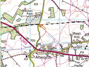
Point 5.2: East of Neston
Park This stretch is one of the very
few places where the Roman Road is visible west
of the Avon. It lies east of Neston Park, which
can be seen to have been delineated by the
remains of the Roman Road, which also formed the
parish border here. It is best approached from
the village of Atworth to the south.
|
How to reach Wansdyke.. At Medley
Cottages
(all
crossroads, etc. carry a link to UK Streetmap.co.uk).
From the
west:
By car from
the directions of Bath or the M4.
From Bath: follow the A 4 to
Chippenham, and at Box take the A 365 to
Melksham. At Atworth take the minor road left to Neston, until
you reach Medley Cottages. Here the Roman Road can
be found crossing the road at a right angle, but
any remains should be visible to your right
(east).
From the M4: take the motorway exit
nr. 18 at Dodington Ash, and follow the A 46(T)
south to Bath. You’ll pass the 577AD
battlefield of Dyrham, which may be well worth a
visit. Anyhow, continue to the Batheaston roundabout. Then continue as
described above.
From the
north:
By car from
the direction of Chippenham.
From Chippenham: follow either the A 4
to Box, or the A 350 to Melksham, and at either
destination, take the A 365 to Atworth. At
Atworth, take the minor road north and continue
as described above.
Alternatively from Chippenham: take the minor roads across the
country, which are much more beautiful and quiet.
Take the A 4 to Corsham, and there follow the B
3353 to Gastard. But before leaving Corsham, go right just after crossing
the railroad to Leafield and Neston, which you
can reach from different directions. The crossing you need to find leads
to a road south through Neston Park (which I hope
is open to the public!), that crosses the Roman
Road north of Medley Cottages.
From the
east:
By car
from the direction of Melksham.
Follow the A 365 to Atworth, then continue as
described above.
From the
south:
By car
from the directions of Bradford-on-Avon or
Trowbridge.
From Bradford: take the B 3109 to Bradford Leigh,
there go right to Atworth, there cross
the A 365 and continue as described above.
From Trowbridge: take the A 361 to Devizes, then
the A 350 to Chippenham and the A 365 to Atworth,
then continue as described above.
|
Click on the
map.
|
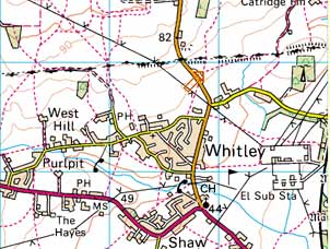
Point 5.3: just West of the
river Avon This stretch is possibly the best
place to see the Roman Road west of the Avon. The
remains of the Roman Road, which extend to a mile
or more here, can be observed on both ends of the
B 3353, and several footpaths lead to it. Remains
can be seen from the main power lines up to the
railwayline.
|
How to reach Wansdyke.. At
Westlands Farm, Whitley
(all
crossroads, etc. carry a link to UK Streetmap.co.uk).
From the
west:
By car from
the directions of Bath or the M4.
From Bath: follow the A 4 to
Chippenham, and at Box take the A 365 to
Melksham. At Shaw take the B 3353 to Whitley and
Corsham. Take note: after leaving Whitley, about
500 metres after crossing the main power lines, a
by-road can be found to your right – you
best park there. From here, two
footpaths go north and east, both leading to
remains of the Roman Road. Other remains can be
seen west of the B 3353, about where the mast of
the power lines is closest to the road.
From the M4: take the motorway exit
nr. 18 at Dodington Ash, and follow the A 46(T)
south to Bath. You’ll pass the 577AD
battlefield of Dyrham, which may be well worth a
visit. Anyhow, continue to the Batheaston roundabout. Then continue as
described above.
From the
north:
By car from
the direction of Chippenham.
From Chippenham: take the A 350 to
Melksham, which crosses the Roman Road at Inwood Copse. Continue to Beanacre,
where you best take the minor road right to Whitley. Go right
again at the B 3353, and continue as described
above.
Alternatively from Chippenham: take the A 4 to Corsham, and there
follow the B 3353 to Gastard. And Whitley. Look
for the by-road on your left, which should appear
before you cross the main power lines.
Best park there and continue as
described above.
From the
south:
By car
from the direction of Melksham.
Take the A 365 to Shaw, go right to Whitley and
continue as described above.
From the
east:
By car
from the direction of Calne.
Follow either the A 4 to Chippenham, or the A
3102 to Melksham, then continue as described
above.
|
click here to return to 'Mid'
Wansdyke, section 5.
|
