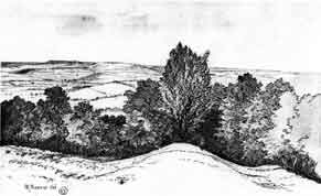
Stantonbury Iron Age camp
After it reaches Stantonbury Hill,
Wansdyke joins once again with the defences of an
Iron Age hillfort. Stantonbury Camp, which rises
about 60 metres over the surrounding land, lies
halfway West Wansdyke and dominates most of the
dyke in both directions. From here on can see
both Maes Knoll in the west and Odd Down to the
east, but also the Avon valley and the Cotswolds
to the north. This dominating view has led
scholars to believe that Stantonbury was the
prime reason for building Wansdyke as far south
where it is, not directly controlling the traffic
of the Avon valley. If you choose an area of West
Wansdyke to visit, I can recommend this one.
The Iron Age defences are much
reduced today. They may originally have
incorporated large stones, some of which can
today be seen on the south slope, having fallen
downhill at some point. Though I cannot vouch for
it, I could imagine that the original defences
were torn down after the Roman conquest in the
first century. The West Country is known to have
resisted the Roman advance fiercely, although
this may only have happened in Dorset. This view
may be strengthened by the construction of the
eastern enclosure. This enclosure has three banks
or terraces, which surround the east end, but
fade out on the south slope. No defences can be
found on the south side, but a further inner bank
turns to a parallel course with the north wall.
This gives the impression that the three banks
once formed a formal entrance to the fort, but
that it was never really finished. Could it be
that it was constructed as an annexe for newly
arrived refugees from the south? Only research
could shed light on this question. During or
after the Roman occupation, the northern defences
were refurbished at some point, probably when
Wansdyke was built (below).
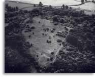
According to Fox and Fox, the hill
top had been ploughed in 1956-7, but the land was
turning into wasteland and going back to shrubs
in 1960. This is the situation which is
represented by the air-photo. Here you can see
the quite overgrown hillfort from the east, with
the A 368 in the background. Burrow mentioned
that by 1973-4, the top was cleared again,
allowing him a better judgement of its defences.
I have not visited the site and therefore
can’t say much as to its present condition.
The easiest approaches are from the north-west
and the east, which is also where Wansdyke can
still be seen.
Stantonbury and Wansdyke
It has been suggested by Fox &
Fox that Wansdyke did not actually use
Stantonbury Camp, the ditch stopping short of the
Iron Age defences by several metres. However,
Burrow showed in 1982 that this was incorrect.
Although the western slope is much disturbed by
quarrying and the lower slopes by cultivation,
Wansdyke can still be traced quite well at
several points on the hill. As with Maes Knoll,
the northern defences are more prominent than
those on the south side. As Wansdyke joins the
defences here, it can be argued that, as was the
case at Maes Knoll, the northern defences were
refurbished when Wansdyke was constructed,
neglecting the south side which was without use
for the builders of Wansdyke.
This notion must be strengthened
when one considers the old name of Stantonbury,
which was Marksbury. This name, going back
to an earlier version in AD 941 of Merces
burgh or Maerec’s burh, is in
essence the same as that of Maes Knoll, and means
boundary fort. There can be no doubt that
both hillforts, used by Wansdyke as dominating
viewpoints rather than strongholds, were later
clearly seen as part of a border.
Wansdyke joins Stantonbury at its
north-western corner, the ditch and counterscarp
ending in the ditch of the northern bank. To me,
this suggests that the northern defences were
refurbished before Wansdyke was built, and it has
indeed been suggested that this section of
Wansdyke was added only at a later date. Wansdyke
then utilizes the whole length of the northern
bank, leaving the fort at the north-eastern
corner. Here, it overlies a low bank, but uses a
slightly higher bank behind it.
Wansdyke leaves Stantonbury from
the north-eastern corner, overlaying one of the
banks of the eastern enclosure.
|
|
Click
on each picture to enlarge it. 
Stantonbury
as seen from Compton Dando.

Stantonbury - north defences looking west, with
Compton Dando and Maes Knoll behind

Stantonbury Camp from the air, 1956.

Wansdyke at
Stantonbury Hill showing Wansdyke with a track
passing through it.

Still at
Stantonbury Hill, nearer the bottom of the hill
were it is very overgrown.

Wansdyke leaving Stantonbury from the
north-eastern corner.

Wansdyke
on the right with trees growing out of it.
|