Wansdyke home I What's New I Sitemap I Bibliography I Vortigern Studies l POLLS I LINKS l Sitemaster I FAQs
search l about Vortigern
Studies l Messageboard I Games I Arthurian
Collection I View Guestbook I Sign Guestbook
| Vortigern Studies > Wansdyke > West to East > Section 8 |
Vortigern Studies Index
.Wansdyke Project 21 |
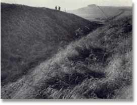
Wansdyke now runs down to the modern Devizes road in a very straight line, which it crosses at Shepherds’ Shore. This is possibly the best-known section of Wansdyke, for everybody passing along this much-frequented road is bound to observe the very obvious course of the earthwork to the west and east of the road. Though parking is troublesome here, the very beautiful pictures displayed of this section were made by two American visitors who dared to.
Indeed, as we can observe from this beautiful view of east Wansdyke towards Tan Hill, it pays off! (click here to enlarge the summer or the winter image)
Wansdyke runs on in a straight line across Bishop's Canning Down, but a small bend occurs just before Brown’s Barn, where Wansdyke uses one side of a Romano-British enclosure. Just beyond that, Pitt-Rivers dug a second section (1890) after the one encountered above, and he found again evidence of 1st, 2nd and 3rd century date, which proved once more that Wansdyke was to be dated to Late or Sub-Roman times.
Wansdyke skirts the steeps heads of the combes that flow away to the north, and which must prevent lateral movement, canalising any line of assault. From Tan Hill, practically the whole line of Wansdyke is visible. Westwards to Morgan’s Hill, and eastwards towards the low ground beyond Milk Hill, up to the wooded reaches of Savernake Forest, where Wansdyke is now thought to end. It is not a strange thought to suppose that East Wansdyke may have been planned from this point by the builders. Here we encounter more of the aforementioned earlier earthworks, although all on a much minor scale when compared to Wansdyke. Wansdyke rolls right over these, submerging them as it were, leaving just a small hump. Directions to Section 8 can be found here. Follow Wansdyke further through Section 9
Several images by kind permision of David Craig, Jake Livingstone and Joe Boyles. |
VortigernStudies and
Wansdyke Project 21 are copyright © Robert Vermaat 1999-2002. |